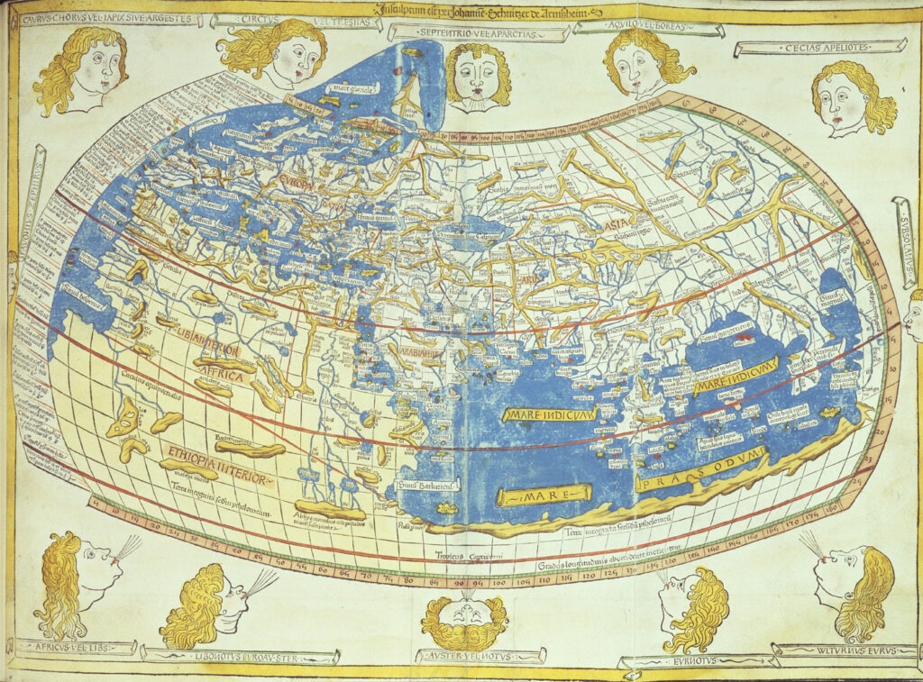
A significant milestone in the history of cartography is the Ptolemy World Map, which the Greco-Egyptian scholar Claudius Ptolemy created in the second century CE. This groundbreaking map, included in his eight-volume treatise Geographia, revolutionized the way we perceive and navigate the world. For over 1400 years, it served as the primary reference for geographers and explorers, shaping our understanding of the Earth’s geography and inspiring countless voyages of discovery.
The Architect of the World Map: Claudius Ptolemy
Claudius Ptolemy, a polymath of exceptional intellect, excelled in various fields, including mathematics, astronomy, geography, and music. His magnum opus, Geographia, compiled and synthesized geographical knowledge accumulated over centuries. Within this work, the Ptolemy World Map emerged as a crowning achievement, representing the first systematic attempt to depict the entire known world on a grid system based on latitude and longitude.

Ptolemy’s map was a marvel of its time, incorporating innovative cartographic techniques that set the stage for future advancements. He meticulously compiled data on locations, distances, and landmarks, drawing upon information from travelers, merchants, and military expeditions. To represent the Earth’s curvature on a flat surface, he employed a sophisticated projection system known as the conic projection, which minimized distortions in certain regions.
The Gridded World: A Paradigm Shift
The introduction of a grid system on the Ptolemy World Map marked a significant departure from previous mapmaking practices. By assigning latitudes and longitudes to various locations, Ptolemy established a standardized method for pinpointing positions and measuring distances. This gridded approach revolutionized navigation, enabling sailors and explorers to accurately chart their courses and determine their positions at sea.
The Ptolemy World Map depicted a world spanning from the Canary Islands in the west to the eastern shores of Asia, encompassing the Mediterranean, Europe, Africa, and parts of the Indian Ocean. While the map contained inaccuracies and omissions, particularly regarding the size and shape of continents, it offered a remarkably comprehensive picture of the world known to the ancient Greeks and Romans.
Despite its groundbreaking nature, the Ptolemy World Map presents a curious anomaly: an unexplained angle between the grid lines and the actual parallels and meridians. This discrepancy, known as the “Ptolemy Angle,” has puzzled scholars and cartographers for centuries, with various theories attempting to explain its origin. Potential explanations range from mathematical errors and cartographic distortions to the influence of magnetic declination or even access to lost knowledge from ancient civilizations.
A Legacy of Inspiration and Exploration
The Ptolemy World Map, despite its limitations, remains an inspirational symbol of human curiosity and the quest for geographical knowledge. It continues to inspire scholars, cartographers, and explorers alike, reminding us of the transformative power of maps and the enduring legacy of Ptolemy’s groundbreaking work.
Due to its enigmatic nature, the Ptolemy Angle serves as a reminder that even the most ground-breaking accomplishments may conceal secrets that future generations will eventually discover.
As we continue to explore the world and refine our understanding of its geography, the Ptolemy World Map remains a timeless treasure, a testament to the enduring human spirit of exploration and discovery.
Additional Resources:
- The Library of Congress: https://www.loc.gov/
collections/maps/ - *The British Library: https ://www.bl.uk/maps *The National Geographic Society: https://www.
nationalgeographic.org/maps/ - *
The American Geographical Society: https://www. americangeographic.org/
POPULAR TODAY
The Nazi base myth has become a staple of conspiracy theories, often intertwined with broader narratives about hidden agendas and government cover-ups.
